Lampedusa is one of the island of Pelagie – between Italy and Africa – and by far the rabbit beach is one of the most beautiful beaches of the world!It is the largest of the Pelagie archipelago in the Mediterranean Sea and is part of the province of Agrigento. Administratively, together with Linosa, the municipality of Lampedusa and Linosa (of which it is the municipal seat), which has a total of 6,304 inhabitants, forms. With an area of 20.2 km², it is the fifth largest extension of the Sicilian islands. In ancient times his name was Lopadúsa (Λοπαδοῦσσα in Greek).
Geography
The island has an elongated shape and measures from 0 to E, 10.8 km, while at the widest point, from N to S, measures 3.6 km, for a perimeter development of 33.3 km. Geologically it is a Horst and belongs to Africa; as Pantelleria is closer to the Tunisian coasts, away from these 113 km (and 150 km from Malta), than to the Sicilian ones, from which it separates 205 km; the maximum depth of the arm of the sea between Lampedusa and Africa is 120 m.
The highest point on the island is the Sole Tree, at 133 m altitude. Lampedusa is also the southernmost inhabited center of Italy: it is in fact located at the latitude of 35 ° 30 ‘N, further south of Tunis and Algiers.
Places of Interest
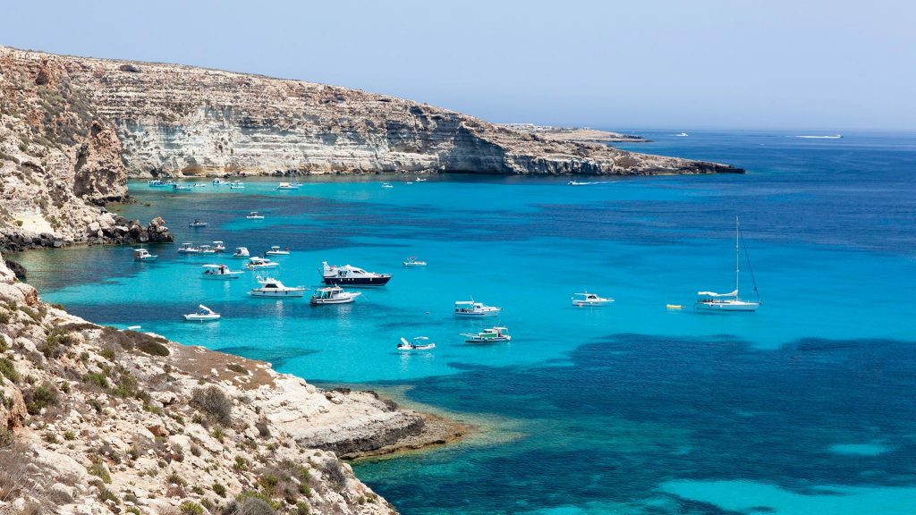
Starting from the small port and going westwards, you will come across the bay where the Guitgia beach is located, after passing this, which closes the harbor inlet to the west, the next stretch of coast is characterized by peaks and coves of morphological interest like Cala Croce and Cala Madonna, particularly deep, Cala Greca and Cala Galera.

After a stretch of higher coast, which surmounts the bay of Tabaccara, we come in sight of the island of Conigli that is a few tens of meters from the coast where the homonymous beach is, and where once Dominic Modugno spent his holidays and where he died, on 6 August 1994. Soon after, there is the Cala Pulcino and the Vallone dell’Acqua. On the northern side of the island characterized by high and indented coasts at Punta Parise we find a particularly large cave and the narrow entrance, which allows access only to swimming, and in which there is a small sandy beach. Continuing westwards, from here begins a stretch of coast characterized by the presence of the Scogli Pignolta, Sacramento and Faraglione, followed by Punta Muro, Punta Cappellone that goes down to the sea, Cala Ruperta, Punta Taccio Vecchio and Punta Alaimo that mark a long particularly wild coast.
Another point of interest is the lighthouse of Capo Grecale, from which along a large bay called the Dead Sea, and frequented by boats and divers attracted by the variety of fish fauna you reach Punta Parrino, which closes the gulf, and Punta Sottile where there are some coves of the southern slope, such as Cala Francese, at the bottom of which there is a beach near the airport.
Climate
The prevailing climate is Mediterranean (thermomediterranean subtype with dry umbrage) and presents transitional characteristics towards the desert climate, summers are generally hot and very dry and the winters are mild and relatively rainy; precipitation is still very low, averaging between 300 and 350 mm per year.
The persistent winding of the winds, due to the low elevation of the island of Lampedusa above sea level (from a minimum of 2-10 m in the SE part to a maximum of 133 m in the NW part), helps to make even the heat bearable summer climate, which turns out to be so rather constant and devoid of the excesses that characterize some areas of the nearby Libyan coast.

The trend of average temperatures confirms these climatic peculiarities, which bring the Lampedusa climate closer to the semi-arid subtropical climate typical of some areas of the south-eastern Mediterranean and make it sensibly different from that of the other coastal towns of Sicily; observing the data of the local weather station it is noted that, in Lampedusa, the coldest month of the year is February, whose average daily temperature is +13.6 ° C, while the hottest month is August, with an average of +26.4 ° C; unlike the Sicilian and Tunisian coastal resorts, where the coldest month of the year is generally January (while the maximum cooling of the sea water takes place in the following month), the profile of the average atmospheric temperature of Lampedusa almost closely follows that of the waters marine, showing the maximum cooling at the beginning / mid February and the maximum heating in the second half of August.
This marked maritimeity, at the low latitude of the island (located close to the 35th parallel north), has the effect of greatly reducing even the seasonal climatic extremes, so it is rare that in winter there are minimums below +8 ° C and that in summer the maximums exceed +32 ° C, except when the sirocco blows, coming from the Libyan hinterland. Because of the marked insularity, however, the climate of Lampedusa is characterized by relatively high relative humidity levels, ranging between 74 and 78% for the entire duration of the year, especially during the winter months, while they are lower with the highest temperatures. summer; however, on the island, the temperature is relatively cooler in the north-western area (Monte Sole Sole, 133 m above sea level) and warmer in the south-east (citadel and port area) because it is lower and less windy.
The island saw snowfall in 1913, 1915, 1942 (the most abundant, with accumulation everywhere, even on the coast) and in 1956. The snow made its appearance again in the southernmost Sicilian land strip December 31, 2014 whitening the streets of the inhabited center and the airport runway.
Geology
Lampedusa and Lampione are part of the African continental plate, and they were raised two million years ago, while Linosa is of volcanic origin. The geological origin of Lampedusa dates back to the Tortoniano, Tertiary period, at the end of the Miocene. This was an era of recovery and explosion of life. The (official) geological map of Lampedusa was written by Mario Grasso and H. Martyn Pedley (1988). The island is a horst and consists of limestone platform and shallow sea (Tortonian coral reef, layers of Calca Pisana).

The type of soil of Lampedusa is mainly characterized by the presence of two types of rock: limestone (calcium carbonate) and dolomite (calcium and magnesium carbonate).
However, the calcareous soil is not uniform: in some places it is friable, in others compact and mixed with siliceous rock (calscisto) so as to require the use of explosives for the excavation. There are significant layers of sandstone of less hardness than lime stone which, exposed to atmospheric agents, becomes porous and easy to break down.

These layers, clearly visible especially along the northern coast of the island (from Capo Ponente to Capo Grecale), form the bed on which rest the hardest layers of dolomite. This determines the phenomenon of cliffs, ie steep slopes and «corbels» formed by the continuous launch of sand and pebbles that dig a «furrow in the rock at sea level, undermining at the base the rocky wall that ends up collapsing and turn into «steep slope».
History
Lampedusa was a resting place for Phoenicians, Greeks, Romans and Arabs who even had a stable colony on the island, with a governor. The Romans used Lampedusa to establish a fish processing plant and for the production of garum, a fish sauce that was very widespread during the imperial age. The Arabs are those who left more footprints on this island because they used it as a landing place during their pirate raids, even long after the official expulsion from Sicily.
Between the Middle Ages and the Renaissance
Subsequently, for a long time, the island remained in a calm expectation of new inhabitants. In 1630 Giulio Tomasi, ancestor of Il Gattopardo, was awarded by the king of Spain the noble title of Prince of Lampedusa and Linosa. In 1760 it was colonized by six Frenchmen followed, after sixteen years, by a Maltese family unit. Later it was a succession of small groups of farmers now headed by Maltese now from English. Even the Russians, along with Prince Grigori Alexandrovich Potemkin, tried to buy the island in order to settle a colony of the Tsarina’s subjects.
The Bourbons and Unification of Italy
A century later, the Tomasi family asked the Bourbons for an adequate financing to be able to conduct on the islands of the archipelago the works necessary for repopulation. In the nineteenth century the Tomasi ceded the Pelagie to Ferdinando II di Borbone. The sovereign did not make a rash purchase and managed to make the archipelago active and productive by settling around 150 inhabitants of Pantelleria who also used in Lampedusa the dammusi, typical constructions of their island.
In 1861 the islanders became subjects of the Kingdom of Italy who established a penal colony in 1872, later suppressed in the following century.
World War II
During the decade before the Second World War, the island was fortified and equipped with numerous naval and anti-aircraft batteries, for the defense and for its important strategic position in the center of the Mediterranean, in an area of maximum transit of the convoys.
The Royal Army presided over the island for several years during the war, keeping it as an advanced post in the Mediterranean in favor of the Axis forces. Until 1943, when during Operation Corkscrew, or the military actions preceding the allied landing in Sicily, the Allies attacked and soon occupied the island.
In the sixties, after decades of waiting, Lampedusa was connected by telephone with the mainland and there was built a power plant and a civil airport.
The LORAN station
In the western part of the island there is a military installation. The NATO base, run by United States Coast Guard personnel until 1994, was home to one of the transmitters of the LORAN radio navigation system and was integrated into a network of similar installations located in Estartit in Spain, Kargaburan in Turkey and Sellia Marina in Calabria to support navigation in the Mediterranean. The transmitter station, which became operational in 1972, was characterized by a 190.5 m high antenna.
On April 15, 1986, the Libyan armed forces of Colonel Gaddafi launched two SCUD missiles. The missiles fell just two kilometers from the Lampedusa coasts. The LORAN network for the Mediterranean is currently inactive and the military base has been returned to the Italian Armed Forces and is home to radar installations.
In March 2011, the former LORAN base was used to house women and minors who had landed on the island.
Bridge between Europe and North Africa
Because of its position between the North African coasts and the south of Europe, the island in the last twenty-five years has become one of the main destinations of the routes of African migrants in the Mediterranean. A 800-seat temporary reception center was built, run by the Ministry of the Interior, which provides for the identification of migrants and their transfer. Migrants and refugees, especially from the Tunisian and Libyan ports, are rescued at sea by the Coast Guard and / or the Guardia di Finanza patrols.
The first landing took place in mid-October 1992 and concerned 71 North Africans. After a month of stay on the island, and having been kept by the local parish and the population, in the absence of indications from the authorities, a fundraiser was organized to pay for the trip to Empedocle port.
The first shipwreck recorded with loss of life occurred on April 25, 1996, when twenty-one Tunisians drowned because of the prohibitive weather conditions.
On June 28, 2008, the Lampedusa Gate – Porta d’Europa, a work of art by Mimmo Paladino dedicated to emigrants dead and missing at sea, was inaugurated in Lampedusa. The promoters of the project are Amani Onlus, Alternativa Giovani di Lampedusa and Arnoldo Mosca Mondadori.
In 20 years, the island has seen about 400,000 migrants land. At least 15,000 are believed to have lost their lives at sea trying to reach it.
The maximum inflow was reached between March and April 2011 when there were 6,500 migrants on the island, compared to about six thousand residents.
On 8 July 2013, Pope Francis made his first apostolic trip to Lampedusa, on the theme of welcoming migrants.
On 3 October 2013, a boat loaded with migrants was shipwrecked a few miles from the port mouth, causing 366 deaths and over 20 missing. Following this tragic event, on the proposal of a specially constituted committee, on 15 April 2015 the Chamber of Deputies approved, with 287 votes in favor, 72 against and 20 abstentions, the institution, for October 3, of a “National Day in memory of the victims of immigration “. The Italian Senate then ratified this decision on March 16, 2016.
Island of Rabbits
The island of the Rabbits (ìsula dî Cunigghi in Sicilian) is an Italian island belonging to the archipelago of the Pelagie islands, in Sicily.
The islet, just 4.4 hectares, is located within a bay chosen by TripAdvisor users, as part of the Travelers’ Choice Awards, the most beautiful beach in the world in 2013, in Europe and in Italy in 2014 and 2015.
The island is very close to the coast, so much so that it has rarely been joined to it through an extemporaneous sandy isthmus of 30 meters in length . This is a rare event (the last time in 2008) , due to the wave and low tide, but it is normally possible to stop in that area of the bay without ever plunging completely into the water, since the depth varies from 30 to 150 cm.

Territory
The entire bay of the Isola dei Conigli is part of the Lampedusa Island nature reserve and is therefore heavily protected. It can be accessed only during the day, from 08:30 to 19:30, in order to safeguard the nesting of sea turtles (which usually happens at night, in fact). Since 1995 the entire area has been entrusted to the management of Legambiente, which every year activates the volunteer camps to select the personnel who will supervise the beach during the summer season.
The islet is low, with a maximum height of 26 meters, and completely rocky. The flora and fauna are very similar to those of the North African coast; the beach adjacent to the islet is one of the few areas where Caretta caretta turtles lay their eggs. It is also an important stopping point for migratory birds that make it stop in April and September and the only area (besides in the African areas from which it comes) in which lives a particular species of lizard, the Psammodromus algirus.