The archaeological park of Selinunte is the testimony of the ancient Greek settlement along the banks of the Modione river. Today it is the largest archaeological park in Europe.
The structure of Selinunte
In the archaeological site, on the acropolis there are some temples along with other secondary buildings, while other temples are located on a hill not far away. Many buildings are ruined as a result of earthquakes that occurred in medieval times; however, some anastylosis interventions have allowed almost completely to rebuild Temple E (the so-called Temple of Hera), and to raise most of one of the long sides of Temple C. The sculptures found in the excavations of Selinunte are found mainly in the National Archaeological Museum of Palermo. The most famous work, the Efebo by Selinunte, is an exception, and is now exhibited at the Museo Civico di Castelvetrano.
The History of Selinunte
Selinunte owes its name to the ancient cultures of Celery (σέλινον in Greek) in the area. The city had a rather short life having been built and destroyed within 240 years, but still had a population that touched 100,000 inhabitants. Selinunte was founded in 650 BC along the coast of the Mediterranean Sea as a settlement under the Megara Hyblea between the Belice valley and the Modione valley.
Selinunte destroyed by Carthaginians
Selinunte was destroyed during the war against the Carthaginians under the command of Hannibal Mago, and before the aid of the Syracusan allies could reach only 2,600 inhabitants they managed to escape by sheltering in Agrigento. Despite the resolution of the war against Carthage, Selinunte was never inhabited except with sporadic settlements.
Monetization of Selinunte
It is among the first cities of Sicily to mint coins, dated around 550-530 BC, around the same time as Himera. In the first Selinunte coins, such as Himera, he used the technique of the incuso square, a characteristic technique of archaic Greek coinage. On the obverse is the leaf of celery, (“talking type”); on the reverse side there is the incused square. The coinage will undergo an interruption in 480 BC, coinciding with the defeat of the Carthaginians, supported by them, in the battle of Imera. Emissions resumed towards 461 with the same monetary foot of Syracuse, ie a tetradrachm weighing 17.40 g. As types of the new coin it will adopt on the obverse the quadriga with Apollo and Artemis, on the reverse side the personification of the Selinus river in the act of making a sacrifice.
The Archeological Park
The archaeological park of Selinunte, today the largest in Europe, was established by the Sicilian Region in 2013. It has an area of about 270 hectares and can be divided into the following areas:
- The Gàggera hill (to the west, with the sanctuary of the Malophòros)
- The Acropolis (in the center, with temples and fortifications)
- The Manuzza hill (to the north, with the ancient town)
- The eastern hill (to the east, with other temples)
- The necropolis
There are two entrances to the park. One from the east side of the hamlet of Marinella di Selinunte (eastern hill), and one from the west side from the hamlet of Triscina di Selinunte (sanctuary of the Malophòros).
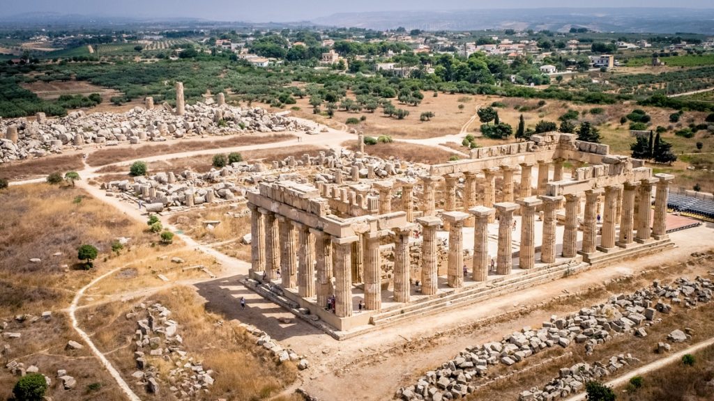
The Acropolis of Selinunte
The Acropolis is a limestone plateau which to the south is overhanging the sea, while to the north it narrows to 140 m. The settlement, roughly trapezoidal in shape, was enlarged towards the north at the end of the 6th century BC. with a formidable wall with steps (about 11 m high), and surrounded by walls – restored and modified several times – made up of curtains in squared blocks with a fill of stones (emplècton), and marked by 5 towers and 4 doors. To the north, the acropolis has fortifications with a counter-wall and towers, dating from the early 4th century BC

Manuzza Hill
To the north of the acropolis, on the hill of Manuzza, the modern road (road 6) traces the border of an area of roughly trapezoidal shape in which it is assumed that the agora would also be found. The whole area was occupied by the built-up area of the Hippodamian scheme – recognized with aerial photographs – slightly apart from the axis of the acropolis, but with elongated blocks of 190 x 32 m strictly oriented north-south, which was originally surrounded by a wall defensive. Systematic excavations have not yet been carried out in the area, but only essays which have confirmed that the place was inhabited since the foundation of Selinunte (7th century BC), and that it is therefore not a subsequent phase of expansion of the city. After the destruction of Selinunte, this area of the city was no longer restored; the refugees returned following Hermocrates, settled only on the acropolis, as it was more easily defensible. On the Manuzza hill in 1985 a tuff building was found, probably a public building dating back to the 5th century BC. Finally, to the north, beyond the built-up area, there are two necropolises: that of Manuzza and the oldest (7th-6th century BC) in the Galera-Bagliazzo area

The Eastern Hill
On the eastern hill there are three temples which, although arranged along the same north-south axis, however, do not seem to have a single sacred enclosure (tèmenos), as shown by the separation wall existing between Temple E and Temple F. This sacred complex has very strong analogies with the western slopes of the acropolis Caria of Megara Nisea, motherland of Selinunte, a precious element, perhaps indispensable, for a correct discourse on the attribution of cults practiced in the various temples.
Gàggera Hill
On the western hill it is reached by a path that starts from the acropolis and crosses the river Modione. In the district of Gàggera you will find the remains of the oldest Selinuntine sanctuary dedicated to the goddess of fertility, the Sanctuary of Dèmetra Malophòros, dug several times between 1874 and 1915. Complex construction, much altered and equally damaged, was erected in the 6th century BC on the sandy slope of the hill; it probably served as a station for funeral processions which then continued to the necropolis of Manicalunga. At the beginning, the place, certainly without any construction, included outdoor cult practices around some ara; only after the erection of the temple and the high wall of enclosure (tèmenos), it was transformed into a sanctuary.
Do you want to book your trip in the archeological park of Selinunte? Click Here for the official website!